Cargando...
Recursos educativos
-
Nivel educativo
-
Competencias
-
Tipología
-
Idioma
-
Tipo de medio
-
Tipo de actividad
-
Destinatarios
-
Tipo de audiencia
-
Creador
Lo más buscado
-
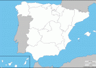
Mapa mudo comunidades autónomas - Blank map of autonomous communities
Esdres Jaruchik Organización
- 4 lo usan
- 2634 visitas
Mapa mudo de las comunidades autónomas de España. // Blank map of the autonomous communites of Spain.
-

Look at the weather map and predict the weather
EduBook Organización
- 3791 visitas
Look at the weather map and predict the weather: What will the weather be like in the north of Spain? And in the south of Spain? Will it rain on the Mediterranean coast? And on the Cantabrian coast?…
-
Identify. Map of the Muslim conquest of the Iberian Peninsula
EduBook Organización
- 3520 visitas
Look at the map and identify the names of the main cities through which the Muslim conquest of the Iberian Peninsula passed:
-

Look at the map. Match the names to the numbers
EduBook Organización
- 3157 visitas
Look at the map. Match the names to the numbers: Pyrenees Ebro river Meseta Sistema Ibérico Tajo river Teide Cordillera Cantábrica Mulhacén Guadalquivir river Cordilleras Béticas
-

Look at the map and answer the questions
EduBook Organización
- 3104 visitas
Look at the map and answer the questions: What is the weather like in your autonomous community? How do you know what the symbols on the map mean? Why do people look at a weather map? What is the…
-
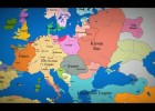
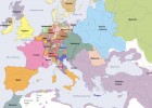
Map of Europe: 1000 AD to present day
Katarina Orlandini Docente
- 3009 visitas
Look at all those changes over the time
-

Video: How to create a 'My Map' in Google Maps
Tiching explorer Organización
- 1 lo usan
- 5134 visitas
The resource consists of a tutorial on how to create personalized, annotated, customized maps using Google Maps.
-
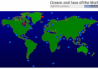
Map quiz: Oceans and seas of the world
Tiching explorer Organización
- 1 lo usan
- 2127 visitas
This resource permits us to learn the names of the seas and ocenas by labelling them on the map.
-

Maps of Spain - Spanish directory, geolocation and map resources for
V&V Books Vicens Vives Organización
- 1990 visitas
Spanish Geographic Information Services, maps of Spain, satellite images, spatial information and resources.
-
Euratlas Periodis Web - Map of Europe in Year 1600
V&V Books Vicens Vives Organización
- 1824 visitas
Online historical atlas showing a map of Europe at the end of each century from year 1 to year 2000: Complete Map of Europe in Year 1600


Te estamos redirigiendo a la ficha del libro...
