Cargando...
Recursos educativos
-
Nivel educativo
-
Competencias
-
Tipología
-
Idioma
-
Tipo de medio
-
Tipo de actividad
-
Destinatarios
-
Tipo de audiencia
-
Creador
Lo más buscado
- Huesos del cuerpo humano
- Descargar ejercicios de ingles
- Dictados para ortografía
- Juegos de tangram de figuras
- Clasificar imágenes
- problemas matemáticas
- Artes escénicas, música y danza
- Repaso de lengua castellana
- Capitales del Mundo
- Conocimiento del medio natural, social y cultural
- Actividades de comprensión lectora primaria para imprimir
- Cocina para niños
- Actividades de geometría
- Paraules amb x
- Descargar ejercicios de lengua
-

Entry test 04 - Weather and climate
EduBook Organización
- 3568 visitas
Look at the map of the meteorological situation in Spain and decide what the weather forecast would be for each place: Burgos Murcia Las Palmas Aragon Pyrenees Badajoz Málaga The sea around the…
-
King Arthur 02
EduBook Organización
- 3091 visitas
Look at the map and answer the following questions. Where was Arthur born? Where is the Round Table? What is the name of the lake where Arthur found Excalibur? Where was Camelot? Where was Arthur buried?
-
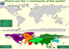
Continents of the world
Smart Organización
- 2 lo usan
- 6558 visitas
SMART notebook lesson designed to help us learn about the differing continents that make up the world. We position the continents on a map. We learn information about different continents, and the…
-

Describe. Europe after the Peace of Westphalia
EduBook Organización
- 3276 visitas
Look at the map and answer the questions: Identify the European possessions of the Spanish and German Habsburgs after the Peace of Westphalia. List the different European States of the 17th century.…
-
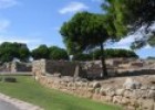
The Greco-Roman settlement of Emporiae
Maria Pallarés Docente
- 2 lo usan
- 5388 visitas
Website that has a street map of the Greco-Roman settlement of Emporiae, satellite images of the ruins of Greek and Roman settlements, and photographs of some archaeological remains, such as the walls…
-

Interpret. Columbus's mistakes
EduBook Organización
- 3180 visitas
Look at the map and answer the questions: What mistakes did Columbus make when planning his voyage to Asia across the Atlantic? Where did he think he had arrived?
-

Observe. The origin and spread of agriculture
EduBook Organización
- 3175 visitas
Look at the map and do the activities: Identify the different agricultural centres and the crops cultivated in each one. When and where did the Neolithic Age spread into Europe?
-
Analyse. The invasions of the 9th and 10th century
EduBook Organización
- 3079 visitas
Look at the map and answer the questions: Which Christian empire dominated Europe in the 9th century? What happened when the emperor died? Which peoples threatened western Europe through their attacks…
-
Ocean life
Proyecto Agrega Organización
- 2 lo usan
- 4366 visitas
Interactive unit designed to help about the ocean. We identify the oceans in a world map. We identify and classify animals. We complete the stages in a sea food chain.
-

Interpret. Tectonic plates
EduBook Organización
- 3048 visitas
Look at the map and answer the questions: Which is the largest plate? Which is the smallest? Which plates are only oceanic? On which plates is the Atlantic Ocean located? On which plate is the Iberian…


Te estamos redirigiendo a la ficha del libro...
